
Those who may be considering being enticed into acquiring land and thus lining the pockets of these speculators should take the time to investigate and consider the impact of such a potential purchase.
An example of such an activity is that at Restronguet Creek, Mylor, Cornwall. This land alone would lead a potential buyer to ask a specific question relating to this site, is it really worth the risk?
Restronguet is now a muddy if picturesque creek, due to the natural process of deposition accelerated by the mining of heavy metals such as arsenic, copper, zinc, iron, lead and cadmium. The only large vessels seen from Weir today are the ships being piloted up Carrick Roads to be laid up in the Fal at Tolverne.
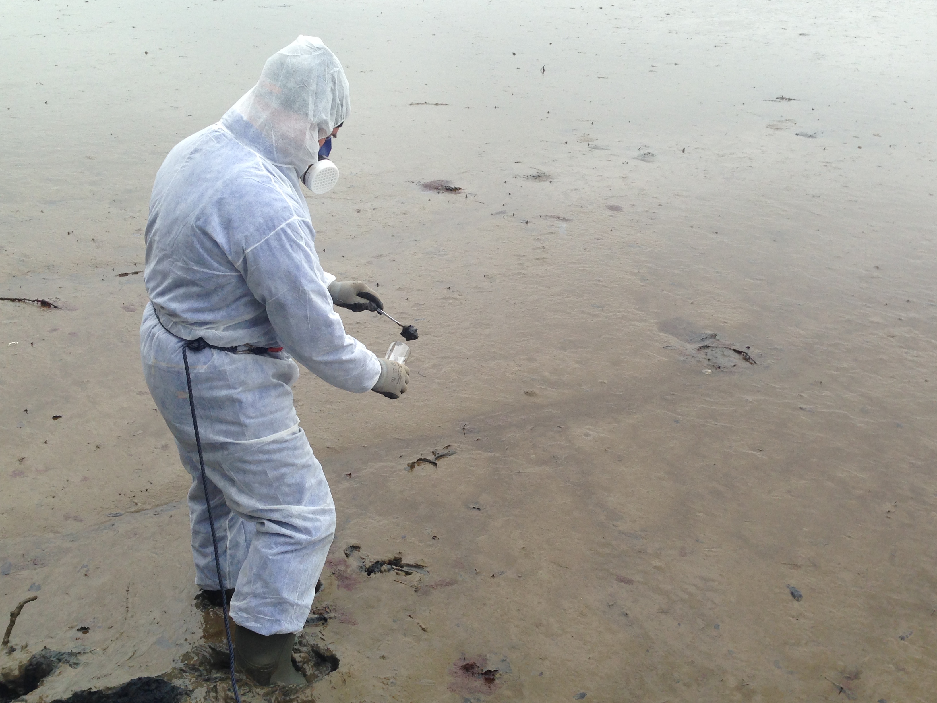
Since 1950 further mining surveys of the creek have been make – a small mining company was operating up the Carnon Valley, and one of the largest and most up-to-date mines in 1970 was opened at Wheal Jane, the drainage from which also flows into the creek. Sadly Wheal Jane has since closed. In 1992, a pollution incident turned the creek reddish brown. It was not just Wheal Jane Mine itself that caused the trouble, for at least 50 abandoned mines are within the catchment area of the Carnon River, and the Country Adit brings into it a flow of mine water from much further away.
The creek changed colour as millions of gallons of acidic water heavily contaminated with metals including cadmium, poured in. Kin Stephens, who owned Weir Beach, spent an hour turning over stones and seaweed to check for signs of life – there was none. He was on Restronguet Creek Society committee whose object is to safeguard the beauty and public amenity value of the creek by making representations to appropriate public authorities, industrial organisations and individuals, to ensure that the creek is not endangered. The society has now started ‘Boatcheck’. Boat watchers alert owners to potential and actual casualties in the creek. In 1994, bodies of dead swans found in the Fal were subjected to autopsies, which revealed excessive levels of lead and zinc in the tissues and severe deterioration of specific glands.
In June 1997, the Port of Falmouth and Truro Health Officer, Andy Hopson, said there were algae in the Fal and he was worried that the toxins, which are produced by the algae, would get into the food chain. Fisherman were advised to refrain from harvesting shellfish. On 20 November 1997, a non-toxic red dye was tipped into the Fal estuary by the Environment Agency. A survey was being carried out by Lyndhurst Oceanographics as part of ongoing work at the disused Wheal Jane Mine. Scientists were recording the movement of the dye within the water and its dispersion. Again, in July 1999, toxic algae were spotted.
Twice a year for the last four years Pamela Thompsett, a marine biologist, has checked the peacock-worm tubes at spring low tides on Weir Beach. Her last visit in 2002 showed plenty of tubes, this proving the water was cleaner. In December 2002 and April 2003 two senior scientists fro m Plymouth University studied the tidal flow and water quality in the pool off the Pandora.
Have you considered the following points?
Do local residents and Cornwall Council support the proposed ideas for a change of use or the redevelopment of this agricultural field, or reliance on dubious permitted development rights?
There is HUGE local opposition to the proposals of sub dividing this agricultural field. This agricultural land forms part of one of only 33 AONB’s in England. AONBs are areas protected by law for their landscape qualities, mainly to conserve and enhance their natural beauty. AONBs are designated solely for their landscape qualities, for the purpose of conserving and enhancing their natural beauty (which includes landform and geology, plants and animals, landscape features) They are designated under the provisions of the 1949 National Parks and Access to the Countryside Act, in order to secure their permanent protection against development that would damage their special qualities, thus conserving a number of the finest landscapes in England for the nation’s benefit. The Countryside and Rights of Way (CROW) Act 2000 bought in new measures to help protect AONBs further. The role of local authorities was clarified; this now includes the preparation of management plans to set out how they will care for their AONBs.
Here are some links to Government websites explaining the high levels of protection afforded to AONB’s:
Is the erection of any type of structure or fence going to be strongly challenged by Cornwall Council’s Planning Department or Enforcement Department?
Any change of use or quasi leisure use will be challenged by the authorities in accordance with national and local planning policy.
Water
Electricity
Sewerage
Refuse Collection
The access to the field is a popular public footpath with no passing places. Is there adequate safe access down to the field and ability to turn into the site without trespassing onto adjoining land?

Are there traffic and safety issues with regard to passing places for cars and trailers and pedestrians on the popular public footpath?
Do you have a vehicular right of access for purposes other than agricultural?
How much will your financial contribution to the maintenance of the track be?
Are you aware that the only access and exit to the field is from the Carclew Road which has fast moving traffic and poor visibility at the junction which will give rise to serious traffic issues?
Is the site level enough for caravans?
Is there going to be a mooring pontoon without planning permission, which is highly unlikely to be granted?
Is the dangerous sinking toxic mud (ex mineral mining waste) on the foreshore suitable for any recreational activities?
University studies have identified that the past mining operations have lead to increased heavy metal levels in the estuary. Restronguet Creek has been significantly affected and is generally considered to be acidic. High levels of heavy metals include Copper and Zinc whit levels of Arsenic.
Additional sources of pollution would include sewerage discharges on a regular and temporary basis and boat discharges.
See https://projects.exeter.ac.uk/geomincentre/estuary/Main/allmap.htm
Bearing in mind the very steep banks to the foreshore, is access from the field practical or safe?
Is increased activity on the field and foreshore going to disturb the well documented wildlife?
Natural England, RSPB and Cornwall Wildlife Trust closely monitor wildlife in the vicinity.
The marketing information refers to vineyards. Have you ever heard of a vineyard in Britain on north facing land on heavy clay soil being suitable for the growing of vines?
Is the purchase of a very small site with little or no chance of obtaining any planning rights going to be worth any more than agricultural value (currently about £9,000 AN ACRE therefore worth a small fraction of this sum)?
Here is a link to the FCA’s Investment Scams website, in particular land banking of small plots: http://www.fca.org.uk/consumers/scams/investment-scams/land-banking
Are you aware that the field is officially classed as being within one of only 33 AREAS OF OUTSTANDING NATURAL BEAUTY in England and therefore national and local planning policy is to give these areas the highest level of protection. Cornwall Council’s Planning Department has a statutory obligation to protect the landscape and seascape of the area and any proposed development or change of use will therefore be closely examined and challenged?
See the National Association for AONB’s www.aonb.org.uk
Do you still believe acquiring a small plot is a good investment?
“The plots of land no longer have permitted development rights. On the 30th April 2014 Cornwall Council confirmed under the Town and Country Planning (Environmental Impact Assessment) (England and Wales) Regulations 2011 that any development or quasi leisure activities on the 1.03 Hectares of land at Restronguet Creek is Schedule 2 development and hence an EIA is required by virtue of Schedule 2 paragraph 12 of the Regulations.
Due to the exceptionally sensitive nature of the land and its AONB status, there are no longer any permitted development rights on the land. The formal EIA screening opinion bans the stationing of motorcars, caravans, motorhomes, off road vehicles, para gliders, tents or similar camping equipment, preparation of food, retail activities, boats or any form of watercraft, games, parties, concerts of Barbeques, and fishing from the shore. In addition the erection of sheds for storage or any other purpose, fences, jetties, slipways or laying of moorings or outhauls and the construction of pathways, byways, bridle paths and roads.”